Weather Maps
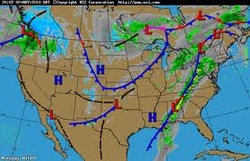
The
weather map is created by national or regional weather agencies and is intended
for use by forecasters. Weather maps generally encompass an entire nation or
group of nations (Engelbert, 1997, p. 428-429). The data collected is examined
for patters in air pressure and temperature (Engelbert, 1997, p. 428-429).
Meteorologists, then determine the locations of fronts, regions of high and low
pressure, the dividing line between temperatures below freezing and above
freezing, and the movement of storm systems. These patterns are labeled on the
map using symbols which include, but are not limited to rain, thunderstorms, snow, fog, and smoke
("Map Symbols", 2004). The
symbols also show the state in which the condition of weather is in, such as
scattered, clear, and overcast.
Isobars
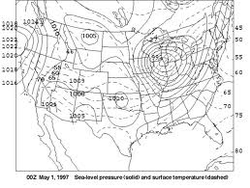
Many weather maps contain a series of lines known as isobars
(Engelbert, 1997, p. 429). Isobars are lines that connect points of equal air
pressure (Engelbert, 1997, p. 429). Isobars are also guides for wind speed and
direction (Engelbert, 1997, p. 429). The closer the isobars are to one another,
the steeper the gradient and hence, the stronger the winds (Engelbert, 1997, p.
429).
